
Bike train rider Elaine organised her University of the 3rd Age (U3A) group for a leisurely ride along the bike train route. Here is their informative log of the ride plus lots of fascinating historical notes.
U3A Bikers ride from Denmark Hill: Parks, quiet roads and super-highways
Friday 11th November 2016
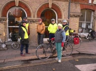
Here is the group of seven happy bikers, gathered outside the cafe in Windsor Walk, next to Denmark Hill Station and all ready to ride!
Elaine and Niesje, our tour leaders, gave a well-researched summary of the day’s route, taking us through quiet SE London roads to the green spaces of Brunswick and Burgess parks, and cycling-on-the-pavement lanes on the New Kent Road,
The route would take us round the Elephant and Castle by-pass and then on the new TfL segregated highway to the Thames at Blackfriars Bridge.
We were to discover the route of a long-forgotten canal which had connected what is now Peckham Square to the River Thames.
We paused just long enough to admire the newly-constructed heliport on top of King’s College Hospital.
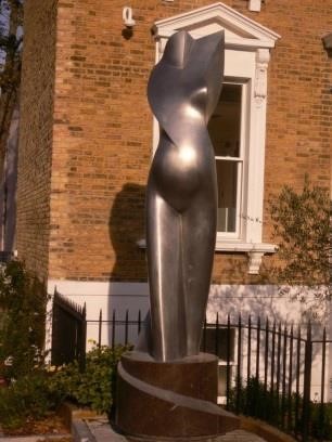
At the bottom of Windsor Walk is a sculpture “Maternity 2015” showing a torso of a pregnant woman and marking the opening of the adjacent Foetal Medicine Research Institute.
Proceeding along Camberwell Grove, we followed the Southwark Cyclists bike train route to our first stop, the churchyard of St Giles Church. The present church was built in November 1844 and the architects were George Gilbert Scott and W B Moffat.
Here we crossed Peckham Road into Brunswick Park, enjoying the glorious golden autumn colours in this small park.
Nearby, we stopped at Benhill Road Nature Gardens. The focus of this small open area is “to provide access to nature for the local community and wildlife education for local schools”.
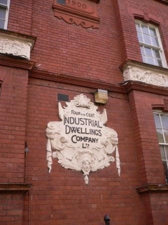
At the top of Edmund Street was a fine 1900 red-brick building with a very ornate plaque reading “Four percent Industrial Dwellings Company Ltd”.
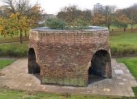
Close by was the entrance to Burgess Park, with a long straight path which passed below a bridge standing in isolation; this was once a bridge over a canal. Further on we passed the well-preserved remains of an old lime-kiln.
The next stop was at the Chumleigh Gardens.
These “world gardens” are designed to reflect traditional English, Asian, Mediterranean, Oriental and Caribbean planting.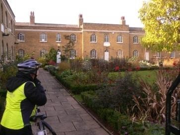
These beautiful tranquil surroundings were a good place to observe the two minutes’ silence on Remembrance Day.
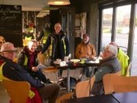
We stopped at the park café for coffee and toast and planned the remainder of the route.
As we were setting off again, Peter produced an old black and white photograph of three ladies in long skirts on their bicycles; we were able to re-create the scene, with Elaine, Niesje and Jean!
The route took us past the Burgess Park ponds and to St Georges Way (surely Wells Way, ed) which we crossed by St Georges Church.
The fine red building here was the Public Baths and Washhouse and we paused to admire the Camberwell Beauty butterfly done in tiled decoration on the gable end.
Northbound on quiet urban roads we passed the end of East Street
Market and arrived at the Elephant and Castle; here a couple of cycle-ways neatly avoided the busy junction and on dedicated cycle lanes we passed the Imperial War Museum. The redesigned cycle-friendly St George’s Circus led us on to Blackfriars Road with its new TfL segregated highway to Blackfriars Bridge.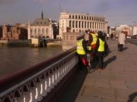
Here we enjoyed the Thames view and, on the other side, a view of
Blackfriars Station and the “twin towers” (or so they appeared) of Bankside and the Shard.
We turned south and headed to the Turkish self -service lunch stop at Ev in Isabella St, before returning along a similar route to Burgess Park.
By leaving the park from the southeast corner, we arrived at the Surrey Linear Canal Park and we were then following the route of the Grand Surrey Canal which once ran from Surrey Docks at Rotherhithe to Peckham.
All that remains now of the 40 feet wide canal are two of the original bridges and parts of the tow-path. This park led to Peckham Library where there was an information board about the canal.
Elaine kindly produced a chocolate treat for us to give us an energy boost for our ride back to Denmark Hill at the end of a very interesting and well-researched ride.
NOTES
St Giles Church There was a church in 1152, before the Victorian church was built. During building the foundations of two former structures were found. St George’s Camberwell was built in 1822 to accommodate the rise in population but disaster struck in February 1841 when a fire broke. The new church was built in November 1844. The architects were George Gilbert Scott and W B Moffat, who went on to design the Albert Memorial and Midland Grand Hotel, St Pancras Station. The stained glass in the East Window was designed by local resident John Ruskin in collaboration with others. The windows in the transepts designed by William Morris were destroyed in wartime bombing, and have been replaced by glass designed by Ninian Comper. The church is dedicated to St Giles, the patron saint of cripples. It is said that Camberwell (Camber was an old English word for crooked) acquired its name from the natural wells found in the area reputed to heal the crippled, or the crooked.
Four percent Industrial Dwellings Company Ltd This was a philanthropic model dwellings company, formed in London in 1885. The foundation of the company followed the United Synagogue’s enquiry into “spiritual destitution” in 1884. The company was founded in 1885 by Rothschild and a board of other prominent, Jewish philanthropists to provide “the industrial classes with commodious and healthy Dwellings at a minimum rent”. The company was founded as a private capital concern, with capital of £50,000 in 5000 shares of £10 each: it is estimated that if the rentals were based on a net return of 4 per cent excellent accommodation could be supplied at a weekly rental of five shillings per tenement; and it is considered that many investors will be found willing and even anxious to contribute their capital towards a scheme, which while yielding a moderate and safe return, will largely tend, not only to improve the dwellings of the poor, but also reduce the high rates now paid for the minimum of accommodation.
Of this, Rothschild himself subscribed £10,000, and even paid for the site of the Company’s first project himself. These first buildings were to be known as Charlotte de Rothschild Buildings, after Lord Rothschild’s mother and took up parts of Thrawl Street, Flower and Dean Street, and George Street, Spitalfields.
The majority of the Four Per Cent Company’s tenants were Jewish. By 1905, it had built six large blocks (known as ‘Rothschild houses’ comprising around 1,500 flats. “Each had two rooms, shared a toilet and kitchen with the adjacent flat, and opened to outdoor halls and stairways. In order to reimburse investors at the promised rate, the six storey buildings occupies no less than 50% of the ground space and tenants paid about 5s to 6s a week (25p to 30p). These grey stone houses were drab and draughty, but they were also solid and sanitary, and were probably better flats than those in other projects of the time.” In 1952, it was renamed the Industrial Dwellings Society (1885) Ltd. and is today known as IDS. The IDS manages over 1,400 properties in a number of the London Boroughs. Its current president is Sir Evelyn de Rothschild, a descendent of the banker Nathan Mayer Rothschild, who founded the Society.
Burgess Park is now sited on the former Camberwell Basin and at Peckham the canal head became the site of today’s Peckham Square. Burgess Park surprises many people that it is a recent green space and only acquiring its present name in 1974. For most of the nineteenth century this vast area was covered with houses, streets and industrial buildings. In 1943 the houses were demolished and people moved on to new estates.
The park is named after Councillor Jessie Burgess, Camberwell’s first woman Mayor. Burgess Park was carved out of a highly built-up area of the city. Virtually all the land now occupied by the park was previously housing, industry and transport infrastructure. The idea for Burgess Park came out of the 1943 Abercrombie plan for open spaces in London. The Grand Surrey Canal was closed in the early 1970s, which terminated at Addington Wharf on Walworth Road. The Canal served the Surrey Commercial Docks, and the area near Camberwell was full of 19th century streets, houses and industrial buildings (including a ginger beer factory), many of which had suffered heavy bomb damage during WWII. The stretch of canal now incorporated in the Park is the site of Camberwell Wharf, which was virtually straight. There are listed buildings in the Park, remnants of the streets which once occupied the site: a lime kiln, the library, baths and wash houses and the former alms houses in Chumleigh Gardens. There are also several bridges, which once used to cross the canal.
Chumleigh Gardens In 1821 the Friendly Female Society, founded in 1802 ‘for the relief of poor infirm aged widows and single women of good character who have seen better days’ opened its alms houses for 20 occupants in Chumleigh Gardens, the north and south sides built in the early 19th century, the west side c.1840. They were occupied until World War II, when they were bombed. After remaining derelict for many years, the alms houses were renovated and now house meeting rooms, offices for Park Rangers and the Art in the Park team of artists. There is an English Garden in front of the buildings and a World Garden with four different styles of garden – Oriental, Mediterranean, African and Caribbean and Islamic – at the back. There is a café round the corner on the north side of the buildings.
The Grand Surrey Canal
The Grand Surrey Canal Act was passed in 1801, authorising a canal through what is now south London from Rotherhithe to Epsom. Its original Engineer was Ralph Dodd. Even before the canal was built the company started making plans for an enlarge ship dock at its entrance which soon began to take priority over the canal. The company, trying to deliver both canal and dock at the same time, ran into financial problems and for a while work stopped on them both. The Dock, or basin, opened first, on 13th March 1807. The Croydon Canal depended on the Grand Surrey for its connection with the river Thames, and this was under construction at the same time. The directors of the Croydon applied pressure to complete the Grand Surrey, as far as their junction, as well they might. This did happen but the relationship between the two companies was never as good as it might have been, with the Grand Surrey Company focusing most on its dock operation. The Grand Surrey was opened as far as Camberwell Road in 1809 but was never built any further. A 1,100 yard arm served Peckham, opened in 1826. The dock was enlarged in 1812. The canal lasted until the 1940s when part of it was abandoned. In 1960 much of it was drained, and in 1970 the dock was closed. A park is now sited on the former Camberwell Basin, and there are few traces of the canal left.
The name “Elephant and Castle” is derived from a coaching inn. The earliest surviving record of this name relating to the area appears in the Court Leet Book of the Manor of Walworth, which met at “Elephant and Castle, Newington” on 21 March 1765. Previously the site was occupied by a blacksmith and cutler – the coat of arms of the Worshipful Company of Cutlers features an elephant with a castle (possibly meant to be a howdah) on its back, which in turn was used because of the use of elephant ivory in handles. Shakespeare mentions the Elephant Lodgings in “Twelfth Night”. In Act 3 Scene 3 Antonio says “In the south suburbs, at the Elephant, is best to lodge.” Although the play is set in Illyria in the Balkans, Shakespeare often used local London references. The theatres were all in Southwark, so Shakespeare’s line may represent an advertisement for a local hostelry. “The Elephant” is a common present-day nickname for the Elephant and Castle and from 1750 the area became more important and the informal name, from the pub at this junction, was adopted.
St Georges Circus: It was built in 1771 to mark the completion of the new roads through St George’s Fields in the parish of Southwark St George the Martyr. In 1905, the obelisk was relocated to Geraldine Mary Harmsworth Park, in front of the Imperial War Museum to accommodate a new clock tower. The clock tower was demolished as a “nuisance to traffic” in the 1930s, but the obelisk did not return to its original location until the late 1990s. At the base of the obelisk is the inscription ‘Erected in XI year of the reign of King George MDCCLXXI’; the inscriptions on the other three sides note the obelisk’s one-mile distance from Palace Yard, London Bridge and Fleet Street.
The circus and obelisk provided a formal termination of Blackfriars Road, a mile long boulevard from the recently-constructed Blackfriars Bridge. At the circus, Blackfriars Road intersected with new and existing highways to Lambeth, Newington, Westminster Bridge and the Borough at Southwark. In local parlance the area was known as the “obliss” and it was a destination point for trams and busses, so passengers could ask for a “tuppeny to the obliss please, guv.” An ‘Act for Improving St George’s Fields’ of 1812 required that all new building around the circus should have concave fronts and should be consistent with a minimum diameter across the Circus of 240 ft. It also specified that no houses “inferior to the 3rd building rate should be erected on the frontages.
Ride leaders: Elaine Gisela and Niesje de Boer; Report by John Clements with notes by Niesje, 14th November 2016
Full report with all the photos can be downloaded here as a pdf: 201611111-to-blackfriars-bridge
Submit a Comment