
 The Five Parks route: a proposal for a leisure cycling and walking route linking the principal green spaces in Southwark
Southwark Cyclists have been running Saturday morning “Healthy Rides” for many years. Routes for these easy-paced leisure rides often include sections through Southwark’s lovely parks. The importance of linking open spaces to make attractive routes is highlighted in the Canada Water Area Action Plan and developers British Land have proposed a “Green Route” from Russia Woodland to Southwark Park. This leads to the thought that maybe this green route could continue and link all the main green spaces in the Borough of Southwark and also extend to the Thames (and beyond when we get the Brunel Bridge). In this way we could create an enticing leisure cycling and walking route that encouraged people to exercise and explore.
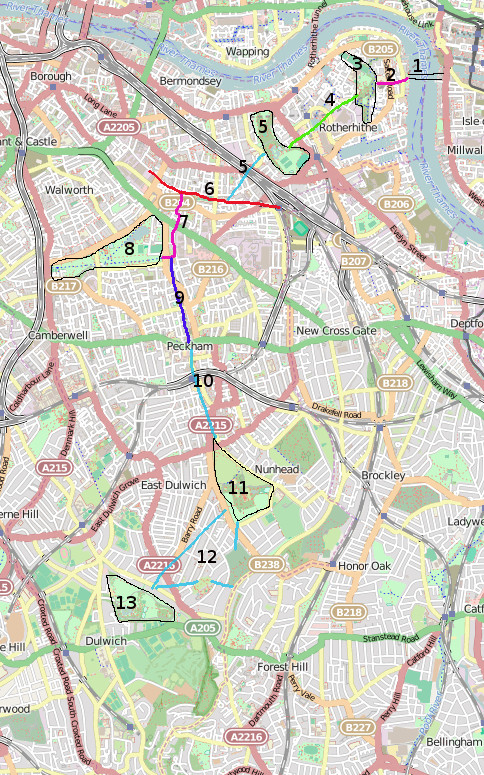
The map shows how this route might look, with an indication of where good quality sections already exist and also where they do not exist.
Key:
- Proposed Brunel Bridge
- Existing NR425 (Connect 2) route
- Russia Woodland
- Proposed “Green Link” in Canada Water Area Action Plan
- Southwark Park, then missing link (marked with second 5)
- Part of Quietway 1
- Existing NR425 (Connect 2) route
- Burgess Park
- Canal Path (LCN 22)
- Missing link
- Peckham Rye Common and Park
- Missing links. 2 alternatives shown. An interesting possibility would be to incorporate Camberwell Old Cemetery and Dawsons Hill – would certainly introduce a hilly challenge!
- Dulwich Park
Would be possible to extend to Crystal Palace Park largely using existing quiet roads.
On existing roads and paths route is 13km (8 miles) long, without including any extra riding within the parks.
Comments do not work on this site, but can be made the Yahoo Group (you will need to register) on the cross posting at:
https://groups.yahoo.com/neo/groups/SOUTHWARKCYCLISTS/conversations/messages/17890
Or direct to Bruce at b.lynn@ucl.ac.uk
Submit a Comment