
Practice cycling a low-traffic route to Central London whilst learning more about Southwark – it’s our guide to the local history you can find along the Bike Train
We know that starting cycling can be a bit daunting, which is why we organise the Southwark Bike Train ride. This shows cyclists how to get to central London along low traffic routes from Nunhead, Peckham and Denmark Hill, via Burgess Park.
The Bike Train route is safe and largely car-free. It’s a good route for many commuters – but it’s also a nice way to practice cycling and navigating longer distances. To make it a bit more fun for anyone that wants to practice walking or cycling the route we have written this guide to the local history of the area. You could ride it yourself, or make it into an afternoon’s walk with friends or family.
The route starts at Denmark Hill train station, goes to Burgess Park (and the Burgess Park café) before travelling up to Blackfriars and the North-South cycle superhighway to Central London. By bike it should take about 40 minutes, and on foot about 1 hour and 30 minutes.
During warmer months we run a group Bike Train ride every Wednesday morning, and during the winter we go once a month (for specific times see our events page).
The Route
To start with you will need to download or print the route to the bike train from our ride-routes page.
You can also download this Discover the history of Southwark by Bike Train guide as a PDF. The PDF doesn’t include the map – it’s just the directions and historical information.
Part One: Denmark Hill to St Giles
Starting at Denmark Hill train station, come out of the station and turn right, then immediately turn right again down Willow Walk. If you look to your left and across the car park you may be able to see a helicopter land at the newly-constructed heliport on top of King’s College Hospital.
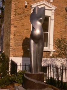
Carry on to the bottom of the road. Here you will find the sculpture “Maternity 2015” showing a torso of a pregnant woman and marking the opening of the adjacent Foetal Medicine Research Institute.
 Carry on around the bend to the end of the road. Turn left into Grove lane and go down the hill to the junction with the Peckham road (at the Hermit pub). Now you need to leave the bike train for a bit, so you could lock your bikes opposite the Hermit or take them with you. Either way – turn right onto the Peckham Road and walk to St Giles Church, our first stop.
Although the present church was built in November 1844, the first known church was built in in 1152. Whilst building the Victorian church the foundations of two former structures were found. St George’s Camberwell was built in 1822 to accommodate the rise in population but disaster struck in February 1841 when a fire broke out. The new church was built in November 1844 and designed by the architects George Gilbert Scott and W B Moffat, who went on to design the Albert Memorial and Midland Grand Hotel, St Pancras Station. The stained glass in the East Window was designed by local resident John Ruskin in collaboration with others. The windows in the transepts designed by William Morris were destroyed in wartime bombing, and have been replaced by glass designed by Ninian Comper. The church is dedicated to St Giles, the patron saint of cripples. It is said that Camberwell (Camber was an old English word for crooked) acquired its name from the natural wells found in the area reputed to heal the crippled, or the crooked.
Part two: Camberwell to Burgess Park
When you have seen the St Giles churchyard return to the Hermit and cross the Peckham road (you may want to use the pedestrian crossing). Go to Kimpton Road, between the Church Street Hotel and KFC, and carry on cycling north. At the top of Kimpton Road turn right onto Elmington Road and carry on until you get to Benhill Road, where you should turn left.
On the road you should see painted signs of a bicycle and the number 23 – this means that you are on “LCN 23” – London Cycle Network route 23. Follow Benhill Road north and it will turn into Edmund Street. Just before you get to the end of Edmund Street you should see a fine 1900 red-brick building with a very large ornate plaque reading “Four percent Industrial Dwellings Company Ltd”.
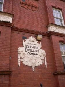 The Four percent Industrial Dwellings Company Ltd was a philanthropic “model dwellings” company, formed in London in 1885. The foundation of the company followed the United Synagogue’s enquiry into “spiritual destitution” in 1884. The company was founded in 1885 by Rothschild and a board of other prominent Jewish philanthropists to provide “the industrial classes with commodious and healthy Dwellings at a minimum rent”. The company was founded as a private capital concern, with capital of £50,000 in 5000 shares of £10 each. The founders claimed that if the rentals were based on a net return of 4 per cent then excellent accommodation could be supplied at a weekly rental of five shillings per tenement. It was thought that many investors would be “willing and even anxious to contribute their capital towards a scheme, which while yielding a moderate and safe return, will largely tend, not only to improve the dwellings of the poor, but also reduce the high rates now paid for the minimum of accommodation.”
Of this, Lord Rothschild himself subscribed £10,000, and even paid for the site of the Company’s first project himself. These first buildings were to be known as Charlotte de Rothschild Buildings, after Rothschild’s mother and took up parts of Thrawl Street, Flower and Dean Street, and George Street, Spitalfields.
The majority of the Four Per Cent Company’s tenants were Jewish. By 1905, it had built six large blocks (known as ‘Rothschild houses’ comprising around 1,500 flats. “Each had two rooms, shared a toilet and kitchen with the adjacent flat, and opened to outdoor halls and stairways. In order to reimburse investors at the promised rate, the six storey buildings occupies no less than 50% of the ground space and tenants paid about 5s to 6s a week (25p to 30p). These grey stone houses were drab and draughty, but they were also solid and sanitary, and were probably better flats than those in other projects of the time.” In 1952, it was renamed the Industrial Dwellings Society (1885) Ltd. and is today known as IDS. The IDS manages over 1,400 properties in a number of the London Boroughs. Its current president is Sir Evelyn de Rothschild, a descendent of the banker Nathan Mayer Rothschild, who founded the Society.
Leaving Edmund Street turn right onto New Church Road. Almost immediately the main road turns right, but you should carry on straight forwards onto the road through the park. It is usually closed to cars.
Part Three: Burgess Park
Going along this path you will go past the “Bridge to Nowhere”, which once crossed over a canal. Further on you will pass the well-preserved remains of an old lime-kiln.
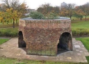 Burgess Park is named after Councillor Jessie Burgess, Camberwell’s first woman Mayor. It surprises many people that it is a recent green space and only acquired its present name in 1974. For most of the nineteenth century this vast area was covered with houses, streets and industrial buildings. In 1943, following the 1943 Abercrombie plan for open spaces in London, the houses were demolished and people moved on to new estates. The area now covered by the park was then full of 19th century streets, houses and industrial buildings (including a ginger beer factory), many of which had suffered heavy bomb damage during World War Two. There are listed buildings in the Park, remnants of the streets which once occupied the site: a lime kiln, the library, baths and wash houses.
We mentioned that the Bridge to Nowhere used to cross a canal – The Grand Surrey Canal. One branch terminated at Addington Wharf on Walworth Road, with the other terminating at Peckham Square.
The Grand Surrey Canal Act was passed in 1801, authorising a canal through what is now south London from Rotherhithe to Epsom. Its original Engineer was Ralph Dodd. Even before the canal was built the company started making plans for an enlarged ship dock at its entrance which soon began to take priority over the canal. The company, trying to deliver both canal and dock at the same time, ran into financial problems and for a while work stopped on them both. The Dock, or basin, opened first, on 13th March 1807. The Croydon Canal depended on the Grand Surrey for its connection with the river Thames, and this was under construction at the same time. The directors of the Croydon applied pressure to complete the Grand Surrey, as far as their junction, as well they might. This did happen but the relationship between the two companies was never as good as it might have been, with the Grand Surrey Company focusing most on its dock operation. The Grand Surrey was opened as far as Camberwell Road in 1809 but was never built any further. A 1,100 yard arm served Peckham, opened in 1826. The dock was enlarged in 1812. The canal lasted until the 1940s when part of it was abandoned. In 1960 much of it was drained, and in 1970 the dock was closed.
You can find out more about the park’s history from the Friends of Burgess park’s website:
Carry straight on through Burgess Park until you get back to a road called Wells Way. On the opposite side of the road you should see the old Library and Swimming Baths, which is now a Boxing Gym and Community Arts Centre.
Cycle or walk along Wells Way to the pedestrian crossing. If you want to go to the next stop (and its café) then cross the road into the park. Otherwise, to continue with the Bike Train carry on along the road – you are allowed to cycle on the pavement once the car parking starts.
If you go into the park then go past the old library. When you meet a lot of other paths turn north to what looks like a set of terraced houses in the park. This is Chumleigh Gardens.
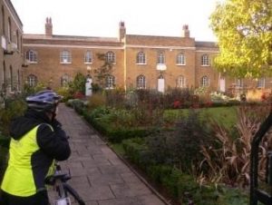 In 1821 the Friendly Female Society, founded in 1802 ‘for the relief of poor infirm aged widows and single women of good character who have seen better days’ opened its alms houses for 20 occupants in Chumleigh Gardens. The north and south sides were built in the early 19th century, the west side in c.1840. They were occupied until World War Two, when they were bombed. After remaining derelict for many years, the alms houses were renovated and now house meeting rooms, offices for Park Rangers and the Art in the Park team of artists. There is an English Garden in front of the buildings and a World Garden with four different styles of garden – Oriental, Mediterranean, African and Caribbean and Islamic – at the back. There is a café round the corner on the north side of the buildings.
Part Four: Burgess Park to Elephant and Castle
When you have finished at the gardens and café you should return to Wells Way and carry on up to Albany Road. Remember that when the car parking starts after the pedestrian crossing you are allowed to ride on the pavement. At the junction with Albany Road turn left, at which point you will have to go back on the road.
Carry on to the next set of traffic lights and turn right onto Portland Street. This is a remarkably quiet street, and it’s odd to think that you are only a few hundred meters from the Walworth Road and Old Kent Road.
Carry on up this road for quite a while. After you cross East Street, and the East Street market, it becomes Brandon Street. Carry on a bit further and you will see a modern and red-tiled building with black and white concrete seats. Turn left into Content Street and onto the cycle track over the square.
When you get to Rodney Road cross straight over and go down Paragon Way until you get to Balfour Street. Turn left, but when motor traffic has to turn left down Munton Street you should carry straight on until you reach the New Kent Road. When you get to the New Kent Road turn left onto the pavement cycle track. Carry on along this track, cross Rodney Place, ignore the first pedestrian crossing and then stop at the second.
If you were to carry on forwards and under the railway bridge you would be at Elephant and Castle. The name “Elephant and Castle” is derived from a coaching inn. The earliest surviving record of this name relating to the area appears in the Court Leet Book of the Manor of Walworth, which met at “Elephant and Castle, Newington” on 21 March 1765. Previously the site was occupied by a blacksmith and cutler – the coat of arms of the Worshipful Company of Cutlers features an elephant with a castle (possibly meant to be a howdah) on its back, which in turn was used because of the use of elephant ivory in handles. Shakespeare mentions the Elephant Lodgings in “Twelfth Night”. In Act 3 Scene 3 Antonio says “In the south suburbs, at the Elephant, is best to lodge.” Although the play is set in Illyria in the Balkans, Shakespeare often used local London references. The theatres were all in Southwark, so Shakespeare’s line may represent an advertisement for a local hostelry. “The Elephant” is a common present-day nickname for the Elephant and Castle and from 1750 the area became more important and the informal name, from the pub at this junction, was adopted.
Part Five: Elephant and Castle to St George’s Circus
There is now a segregated cycle track through Elephant and Castle, but we recommend a route that avoids the whole thing. Use the pedestrian crossing to cross the New Kent Road, then get onto Meadow Row. Cycle down to Rockingham Street and turn left. Go under the railway bridge and to a bike-only crossing over Newington Butts. This takes you into Southwark Bridge Road. When you get to the London South Bank University’s “Perry Library” the road bends right – you should carry straight on along Keyworth Street. Turn left down Ontario Street, cross London Road with the cycle crossing and go down Princess Street.
When you get to the end of Princess Street you meet the North-South Superhighway on St George’s Road. Turn right and follow the superhighway to where it bends right, into Lambeth Road. The Imperial War Museum is on the opposite side of the road. Before this was the museum it was the Bethlehem Royal Hospital – more commonly known as the “lunatic asylum” Bedlam.
If you carry on down Lambeth road you reach St George’s Circus. It was built in 1771 to mark the completion of the new roads through St George’s Fields in the parish of Southwark St George the Martyr. In 1905, the obelisk was relocated to Geraldine Mary Harmsworth Park, in front of the Imperial War Museum to accommodate a new clock tower. The clock tower was demolished as a “nuisance to traffic” in the 1930s, but the obelisk did not return to its original location until the late 1990s. At the base of the obelisk is the inscription ‘Erected in XI year of the reign of King George MDCCLXXI’; the inscriptions on the other three sides note the obelisk’s one-mile distance from Palace Yard, London Bridge and Fleet Street.
The circus and obelisk provided a formal termination of Blackfriars Road, a mile long boulevard from the recently-constructed Blackfriars Bridge. At the circus, Blackfriars Road intersected with new and existing highways to Lambeth, Newington, Westminster Bridge and the Borough at Southwark. In local parlance the area was known as the “obliss” and it was a destination point for trams and busses, so passengers could ask for a “tuppeny to the obliss please, guv.” An ‘Act for Improving St George’s Fields’ of 1812 required that all new building around the circus should have concave fronts and should be consistent with a minimum diameter across the Circus of 240 ft. It also specified that no houses “inferior to the 3rd building rate should be erected on the frontages.
From St George’s Circus you can take the North-South superhighway up Blackfriars Road to Southwark Tube, Blackfriars Bridge, and on into the City of London.
Hope you enjoyed the ride!
The historical facts along the Bike Train were provided by Elaine Gisela and Niesje de Boer, 14th November 2016. Corrections and additions welcome via the discussion group or contact email.